
search
Paris arrondissement map
Arrondissement map Paris France. Paris arrondissement map (Île-de-France - France) to print. Paris arrondissement map (Île-de-France - France) to download. As of January 2008 the city of Paris, within its administrative limits (the 20 arrondissements as its shown in Paris arrondissement map) largely unchanged since 1860, Paris has an estimated population of 2,211,297 and a metropolitan population of 12,089,098, and is one of the most populated metropolitan areas in Europe.
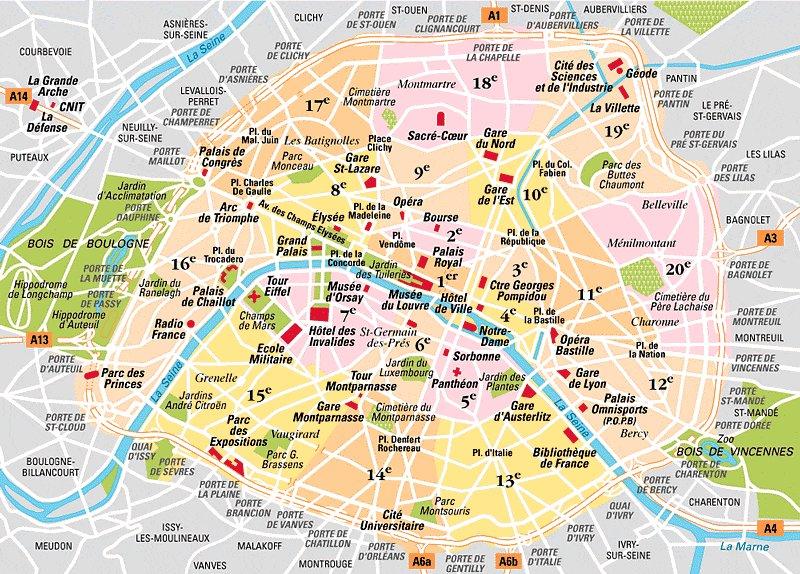
Paris has 20 arrondissement, very uneven; the smallest are in the center and the largest, the 14th district, is more than 8 times larger than the smallest, the 2nd district as its mentioned in Paris arrondissement map. The Bois de Vincennes is part of the 12th arrondissement and the Bois de Boulogne of the 16th arrondissement. Paris is both a commune and the most central department of the Ile-de-France region, which has 8 in total. Three of them surround Paris: Val-de-Marne, Seine-Saint-Denis and Hauts-de-Seine, forming the "Petite Couronne"; on the outskirts, the other four departments make up the "Grande Couronne": Seine-et-Marne, Val-d'Oise, Yvelines and Essonne.
Paris is administrative department 75, and within the department, the city is divided into 20 administrative arrondissements as you can see in Paris arrondissement map. The arrondissements of Paris are set out in the form of a spiral, with the first arrondissement in the centre and the numbers increasing outwards in a clockwise direction.
Paris arrondissements each of which has its own mayor, town hall, and particular features. The numbering begins in the heart of Paris and continues in the spiraling shape of a snail shell, ending to the far east. Parisians refer to the arrondissements by number as the first (premier), second (deuxième), third (troisième), and so on.