
search
Rer b map
Rer b Paris map. Rer b map (Île-de-France - France) to print. Rer b map (Île-de-France - France) to download. Closely linked to the Paris metro, the rer line b is a line taken daily by many passengers, who travel to work or visit the capital. The rer b map has 3 branches, serving the Paris area, and a common central section serving the center of Paris on a north / south axis as its shown in rer b map. The line was extended several times. The rer b 2 branch is the shortest of the line and serves only zone 3 of the network.
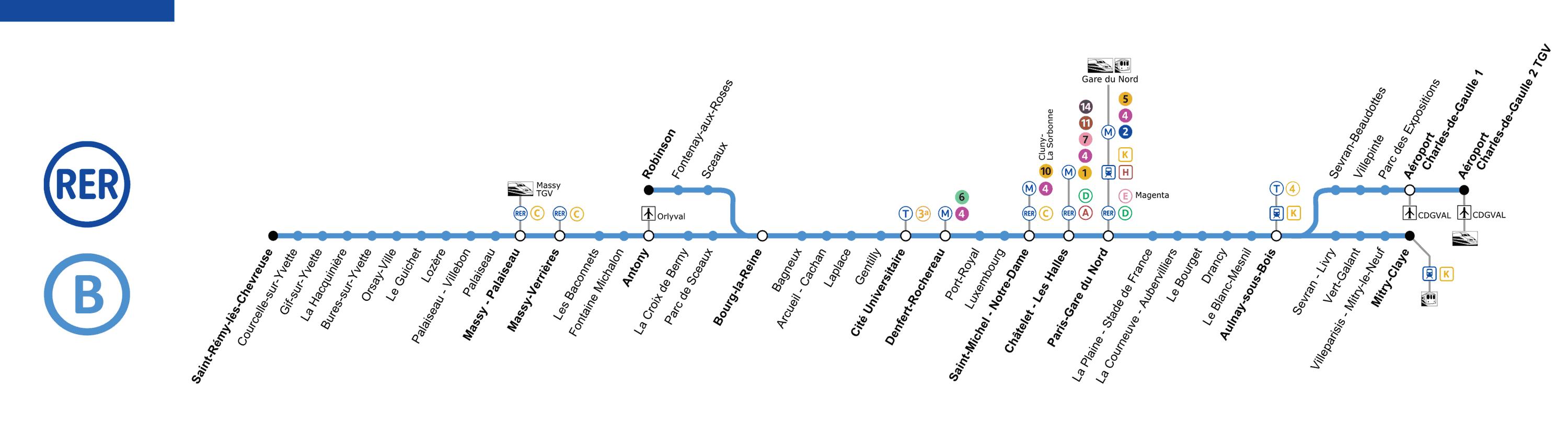
The rer b is a regional train line running through the city of Paris from north-east to south-west. On rer b map It connects Roissy - Charles de Gaulle airport and the towns of Mitry - Claye to the north, the cities of Saint - Rémy - lès - Chevreuse and Plessis - Robinson to the south, via the center of Paris. The RER B is known to serve several airports and train station.
Rer line b runs northeast to southwest and serves 47 stations as you can see in rer b map. It connects, among others, Roissy-Charles de Gaulle 2 and Mitry-Claye airports to Robinson or Saint-Rémy-lès-Chevreuse. Rer line b is the second busiest line and the number of passengers continues to grow. Via Massy-Palaiseau or Saint-Michel stations, passengers can get to line C. From Châtelet les Halles, line b is connected to lines A and D. You have to go as far as Auber to reach Haussmann St-Lazare and line E.
Rer line b extension to the Gare du Nord (1981) and the north (1983) was effected by a new deep tunnel from Châtelet - Les Halles. The southern part of the rer line b (south of Gare du Nord) is operated by RATP, the northern part by SNCF as its shown in rer b map. Trains are owned by either company. Until December 2009, drivers changed at Gare du Nord ; RATP and SNCF drivers now operate their trains all line long. Trains moving from one network to the other at this station is known as the Interconnexion.